


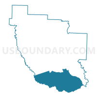
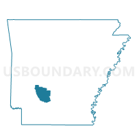
South County Voting District, Clark County, Arkansas
About
Outline

Summary
| Unique Area Identifier | 526101 |
| Name | South County Voting District |
| County | Clark County |
| State | Arkansas |
| Area (square miles) | 134.43 |
| Land Area (square miles) | 134.33 |
| Water Area (square miles) | 0.10 |
| % of Land Area | 99.92 |
| % of Water Area | 0.08 |
| Latitude of the Internal Point | 33.85431600 |
| Longtitude of the Internal Point | -93.09607830 |
Maps

Graphs
Select a template below for downloading or customizing gragh for South County Voting District, Clark County, Arkansas


Neighbors
Neighoring Voting District (by Name) Neighboring Voting District on the Map
- Behestian Voting District, Ouachita County, AR
- Bluff City Rural Voting District, Nevada County, AR
- Broughton Voting District, Nevada County, AR
- Curtis Voting District, Clark County, AR
- Gurdon General Voting District, Clark County, AR
- Gurdon Ward 2, Clark County, AR
- Gurdon Ward 4, Clark County, AR
- Library/New Hope Voting District, Nevada County, AR
- Red Hill Voting District, Ouachita County, AR
- West County Voting District, Clark County, AR
Top 10 Neighboring County Subdivision (by Population) Neighboring County Subdivision on the Map
- Caddo township, Clark County, AR (22,995)
- Red Hill township, Ouachita County, AR (790)
- Boughton township, Nevada County, AR (452)
- Redland township, Nevada County, AR (447)
- Union township, Nevada County, AR (216)
- Bethesda township, Ouachita County, AR (177)
Top 10 Neighboring Place (by Population) Neighboring Place on the Map
Top 10 Neighboring Unified School District (by Population) Neighboring Unified School District on the Map
- Camden Fairview School District, AR (17,872)
- Prescott School District, AR (5,316)
- Gurdon School District, AR (4,430)
Top 10 Neighboring State Legislative District Lower Chamber (by Population) Neighboring State Legislative District Lower Chamber on the Map
Top 10 Neighboring State Legislative District Upper Chamber (by Population) Neighboring State Legislative District Upper Chamber on the Map
Top 10 Neighboring 111th Congressional District (by Population) Neighboring 111th Congressional District on the Map
Top 10 Neighboring Census Tract (by Population) Neighboring Census Tract on the Map
- Census Tract 9539, Clark County, AR (5,472)
- Census Tract 902, Nevada County, AR (4,963)
- Census Tract 9502, Ouachita County, AR (2,787)
- Census Tract 901, Nevada County, AR (2,490)
Top 10 Neighboring 5-Digit ZIP Code Tabulation Area (by Population) Neighboring 5-Digit ZIP Code Tabulation Area on the Map
- 71923, AR (15,637)
- 71857, AR (5,894)
- 71743, AR (4,090)
- 71726, AR (1,435)
- 71962, AR (792)
- 71772, AR (34)